Habitat Improvement at Steigerwald lake NWR
Steigerwald Reconnection Project
Since its designation as a National Wildlife Refuge in 1987, Steigerwald Lake has evolved into a beloved destination for travelers and neighbors from both sides of the Columbia River. Stunning views, meandering trails, and an amazing mix of birds invite a sense of wonder. Now, another evolutionary leap is underway.
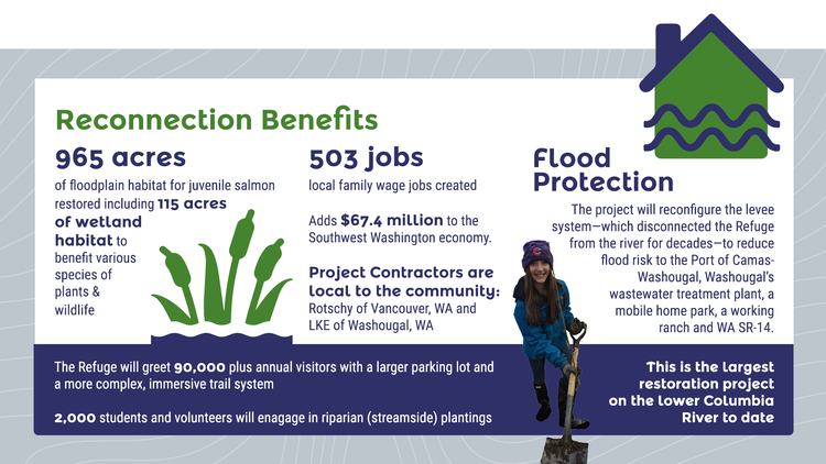
Through the Steigerwald Reconnection Project, the Refuge is poised to fulfill its promise as both a haven for wildlife and an Urban National Wildlife Refuge, greatly enhancing habitat for aquatic and terrestrial species while partnering to address critical community needs.
The project will restore a direct tie between Refuge lands and the waters of Gibbons Creek and the Columbia that has not been seen in generations. As wetland habitat improves, so too will the quality of life for Refuge neighbors, through flood protection, jobs, and the health benefits of a deeper connection to nature.
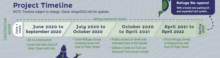
The project timeline explains the main phases of the project occurring between June 2020 and April 2022. It is an approximation and subject to change due to on-the-ground conditions. The timeline was updated on September 29, 2020 to reflect that the Gibbons Creek Art Trail and Seasonal Trail (the interior trails of the Refuge) will remain closed for the duration of the project, until April 2022. By the end of October until April 2021, the public access on the levee trail will be extended East to the fish ladder.
The Latest from Social Media
Our VetsWork intern Sarah has been with us just over a month and has been hard at work learning, removing invasive…
Posted by Lower Columbia Estuary Partnership on Thursday, March 25, 2021
Our props and thanks to the Arbor Day Foundation for their 2021 Columbia Basin Tree Planting Partnership! Arbor Day…
Posted by Lower Columbia Estuary Partnership on Tuesday, March 16, 2021
Blog updates & Special Features
“A ‘Big Year’ for Steigerwald Reconnection: Summer Recap” The 20/20 Blog, November 5, 2020
“What About the Fish? Relocation at Steigerwald Lake NWR” The 20/20 Blog, October 1, 2020
“Roadwork Nearly Complete” The 20/20 Blog, September 17, 2020
“Tree Salvage” The 20/20 Blog, August 7, 2020
“Top Outdoor Alternatives During Steigerwald Lake Closure” The 20/20 Blog, July 17, 2020
“Construction Begins June 1st” The 20/20 Blog, May 18, 2020
SPECIAL FEATURE: “Steigerwald Floodplain Restoration Breaks Ground” September 6, 2019
In the Media
“2020 Construction Kicks Off” Clark County Today, May 13, 2020
“SLNWR is Reconnecting to the River” The Columbian, August 29, 2019
Printable Information
Four-page Informational Handout 11×17 – PDF
Key Dates
June 1, 2020: Construction begins. The existing Refuge parking lot becomes permanently closed. Visitors can access the levee trail via Captain William Clark Park. The Refuge’s interior trails will not be accessible.
June 2020 through September 2020: Washington SR-14 construction will cause intermittent single lane closures in both directions to traffic traveling through Washougal.
July 2020 through April 2022: The interior trails of the Refuge (Gibbons Creek Art Trail and Seasonal Trail) will be closed to public access.
April 15th, 2021: The Columbia River Dike Trail closure will be moved from the fish ladder to the western edge of the Refuge at Index Street.
July 2020 through October 2020 & April 2021 through April 2022: The entire Refuge will be closed for project work, until the re-opening in 2022. This closure includes the levee trail East of Index Street.
Spring 2022: The Refuge re-opens with a new trail system that includes one mile of additional trail, two new footbridges, and additional viewpoints. Gibbons Creek will flow through the Refuge’s floodplain to the Columbia River.
Project details
Refuge habitats will function more naturally by restoring the natural flow and path of Gibbons Creek and removing its diversion structure and fish ladder.
Public and private lands will be protected from the natural ebb and flow of the floodplain by removing 2.2 miles of existing levee and creating two new setback levees. Neighbors and travelers will also see improved flood protection as SR-14 is raised to the 500-year flood level (~five feet above the peak of the 1996 flood) and the capacity of the Gibbons Creek bridge is increased.
Wildlife habitat will increase from restored wetlands and over 200 acres revegetated with native trees and shrubs. Habitat quality will be enhanced by adding large wood debris and other natural features. Removal of the fish ladder and levee will provide unobstructed passage for salmon and lamprey as well as much needed place for juvenile salmon to rest on their challenging migration to the ocean.
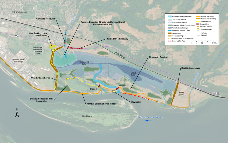
Download a high resolution JPG, courtesy of the Lower Columbia Estuary Partnership
A Community-wide Effort
You don’t create the largest restoration project on the lower Columbia River without a whole lot of help. There are many community partners working together to make this vision a reality:
-
Lower Columbia Estuary Partnership
-
U.S. Fish & Wildlife Service
-
Port of Camas-Washougal
-
Columbia Gorge Refuge Stewards
-
Friends of the Columbia River Gorge
-
National Fish and Wildlife Foundation
-
Camas-Washougal Community Chest
-
One Tree Planted Foundation
-
M Bar J Ranch
-
BNSF Railroad
-
Bonneville Power Administration
-
Washington State Department of Transportation
-
Washington State Department of Ecology
-
City of Washougal
-
Washougal School District
-
City of Camas
-
Camas School District